Showing 112 items matching in lister house gardens
-
 Northern District School of Nursing. Managed by Bendigo Historical Society Inc.
Photograph - Schools 21 and 22
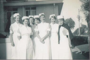
... In Lister House gardens... nurses in garden at Lister House. C 1954.... In Lister House gardens Seven first year nurses Names written ...The Northern District School of Nursing opened in 1950 in to address the issues around nurse recruitment, training and education that had previously been hospital based. The residential school was to provide theoretical and in-house education and practical training over three years. The students would also receive practical hands-on training in the wards of associated hospitals. The Northern District School of Nursing operated from Lister House, Rowan Street, Bendigo. It was the first independent school of nursing in Victoria and continued until it closed in 1989.Black and white photograph of seven first year student nurses in garden at Lister House. C 1954Names written on back. L to R - Verna Hoensch, Heather Midgley, Helen Ryan, Margaret Arnoldt, Ida Moore, Rae Eyles. Lister House, Bendigo. 1954 in lister house gardens, seven first year nurses -
 Hymettus Cottage & Garden
Postcard, Hymettus, 1999
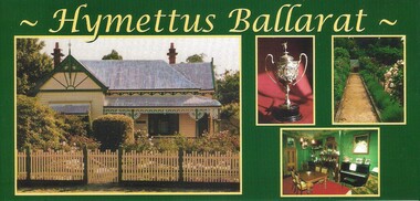
... as promotional material for the then Heritage listed house and garden's... listed house and garden's centenary in 1998. Souvenir, postcard ...Postcards produced for visitors to Ballarat and Hymettus as souvenirs and for posting. These postcards were produced as promotional material for the then Heritage listed house and garden's centenary in 1998.souvenir, postcard, ballarat, hymettus, heritage listing, -
 Northern District School of Nursing. Managed by Bendigo Historical Society Inc.
Photograph - School 23A 1954 -1957
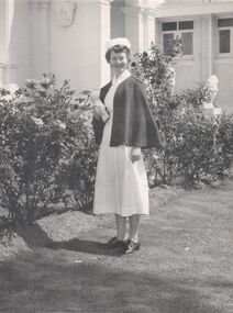
... in front of Lister House Lister House Bendigo 1954. Lister House.... The Northern District School of Nursing operated from Lister House ...The Northern District School of Nursing opened in 1950 in to address the issues around nurse recruitment, training and education that had previously been hospital based. The residential school was to provide theoretical and in-house education and practical training over three years. The students would also receive practical hands-on training in the wards of associated hospitals. The Northern District School of Nursing operated from Lister House, Rowan Street, Bendigo. It was the first independent school of nursing in Victoria and continued until it closed in 1989.Photo of second year nurse School 23A 10 in uniform in front of Lister House Lister House Bendigo 1954. Lister House - Front garden. Nr Elizabeth Joan Thorpe, Mildura, 2nd yr 1954 -57 School 23A. On back in pencil - Nr EJ Thorpe Mildura 2nd yr 1954-57 School 23Asecond year mildura nurse e.j. thorpe, standing in front of lister house -
 Northern District School of Nursing. Managed by Bendigo Historical Society Inc.
Photograph - 2nd Year nurse
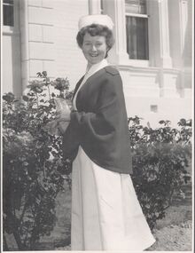
... in front of Lister House Bendigo 1954. Lister House - Front garden... in front of Lister House Bendigo 1954. Lister House - Front garden ...The Northern District School of Nursing opened in 1950 in to address the issues around nurse recruitment, training and education that had previously been hospital based. The residential school was to provide theoretical and in-house education and practical training over three years. The students would also receive practical hands-on training in the wards of associated hospitals. The Northern District School of Nursing operated from Lister House, Rowan Street, Bendigo. It was the first independent school of nursing in Victoria and continued until it closed in 1989.Photo of second year nurse School 23A Ten in uniform in front of Lister House Bendigo 1954. Lister House - Front garden. Nr Elizabeth Joan Thorpe, Mildura, 2nd year. 1954 -57 School 23A. Shield on wall in background - Dr Neptune Scott's family coat of arms. second year mildura nurse e.j. thorpe, standing in front of lister house -
 City of Moorabbin Historical Society (Operating the Box Cottage Museum)
Newsletter, CMHS Moorabbin Mirror Vol 3 August 2015, Moorabbin Mirror Vol 3 August 2015, August 2015
This is Vol. 3 of the Moorabbin Mirror produced by CMHS members Fran & Holger Bader , Valma Sharp August 2015 The Moorabbin Mirror reflects the history and heritage of the former City of Moorabbin — derived from Mooroobin, ‘a resting place’ in the Bunurrung spoken language. In 1994, the City of Moorabbin was integrated into the Cities of Bayside, Glen Eira, Kingston and Monash. Members are informed of the Heritage Display at Stanley's Menswear, Bentleigh East, in conjunction with Glen Eira HS, Market Garden Display at Bendigo Bank Ormond and the Sandbelt Milestones at Brighton Cemetery, Godfrey Street Community House, St Peter's Church & School, the ongoing Gallipoli Centenary and Moorabbin Saints AFL team at Linton Street. Dates for Committee Meeting, General Meeting and the upcoming AGM in October. Photos from The Booklet and Leaflet Launch on May 13th, a request for information about the Womens’ Farm Mordialloc c 1916 , advertisements for the Bayside Arts & Cultural Exhibition featuring Tommy Bent and the RHSV Exhibition re MacPherson Robertson featuring the bust made by August Reitman at Box Cottage . Open Days are listed with an invitation for new members showing the benefits and duties of CMHS membership. CMHS thanks The Office of the Hon. Andrew Robb AO MP Minister for Trade & Investment, Federal Member for Goldstein, who photocopied this newsletter under community printing entitlements. This is Vol. 3 of the Moorabbin Mirror, Newsletter of CMHS August 2015 A4 x 3 paper folded to A5 x 6pp with colour photographs. Moorabbin / Mirror / August 2015 Issue 3 moorabbin mirror, bader fran, bader holger, sharp valma, bent tommy, mordialloc womens farm c1916, gallipoli landings 1915, robertson macpherson, reitman august, godrfrey street community hhouse bentleigh, st peter's church bentleigh east, brighton cemetery, bendigo bank ormond, stanley's menwear bentleigh, glen eira historical society, launch of box cottage museum publications 2015, glen eira city council,east -
 City of Moorabbin Historical Society (Operating the Box Cottage Museum)
Document - Document, statement of fees 1950, c1950
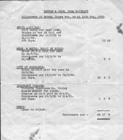
Mr John Herron and his wife Isa Mary Herron purchased the house at 4 Vickery Street Bentleigh in 1950 from Miss M Marriott. He was a descendant of John James an early settler dairyman in Moorabbin Shire and Miss M Marriott was a descendant of the early settler market gardeners Marriott family. Mr Herron lived there until 1989 and the house was then demolished and turned into a carpark for the busy Shopping precinct of Centre Road, Bentleigh.The Marriott family were early settler market gardeners from 1878 in the area of Dendy’s 1841 Special Survey and John Herron was a descendant of Philip Jones , a chair-maker, who settled in the area of East Brighton, now Bentleigh, in 1852 An original, paper, Statement of Adjustments attached to previous item 00053.3 for purchase of the house at 4 Vickery Street, Bentleigh by Mr John Herron from Miss M Marriott in 1950 Heading - HERRON & ANOR. From MARRIOTT / Adjustment of Rates, Taxes, etc., as at 12th May 1950 / list of costs/ typed in left hand bottom corner – E. & O.E, / Melbourne, / 10th May 1950 pioneers, early settlers, brighton, moorabbin, bentleigh, market gardeners, dairyman, dairy farmer, jones james, jones mary ann, jones martha, jones elizabeth ann, dendy henry, dendys special survey 1841, elster creek, melbourne, jones ethel may, herron isa mary, herron john, tram conductor, marriott m, boothby b b, boothby n b, solicitors, land sales, house sales 1950, real estate -
 Eltham District Historical Society Inc
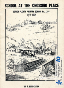
Book, School at the crossing place : Lower Plenty Primary School no. 1295, 1874-1974 / W.F. Henderson, 1974c
23 pages including information on inside covers. Text with black and white illustrations and photographs and map. Contents: Crossing Place Need for a school Residence for the teacher Closure A View of Lower Plenty 1918 Moving day at the Village The Golf Club Depression 1931 Vandals Electricity Grass Fires Cows at School Mothers' Club Women's liberation 1950's Lower Plenty after 1945 Swimming Pool - drowned dreams Long Grass - snakes - meadow hay - Fire Brigade The Royal Visit 1954 School Band Community Centre Our School Hall Trees and Gardens The Library Education 1874-1974 A Teacher's View The Second generation - children of ex-pupils (photo with names) The Third generation - Grandchildren of ex-pupils (photo with names) Head Teachers (list with dates) The Staff 1974 (photo with names) The sketch on the cover shows the Lower Plenty Bridge, toll house and the Plenty Bridge hotel, both no longer there. The bridge is listed in the Banyule Heritage Study and has recently been restored by Banyule Council as a pedestrian bridge - NL 137 March 2001 Paperback; [24] p. : ill. ; 25 cm.lower plenty, state school no. 1295, lower plenty primary school -
 Eltham District Historical Society Inc
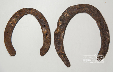
Horseshoe, Two horseshoes, c.1860, 1860s
ELTHAM POLICE QUARTERS & REAR STABLE (FORMER), is listed on the Victorian Heritage Database. The stables are described: "The original single stall brick stables building with loft, built in 1859-60.."These horseshoes were dug up by the owners of the property adjoining the former Eltham Police Station and Court House site behind the stables when working in their garden. Presumably they were discarded adjacent to the stables where the Police horses were kept and over time became covered with soil and other material. They were presented to the Society by the owner during the Local History Centre Open Day held for the Society's 50th anniversary 4 March 2017.Two iron (rusty) horsehoes, one significantly larger than the other; the larger shoe appearing to be not fully manufactured as no nail holeshorseshoe, police residence, police station, brougham street, eltham -
Kew Historical Society Inc
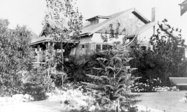
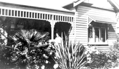
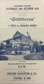
Archive (Sub-series) - Subject File, Kew Historical Society, 'Goldthorns' (Houses, Kew), 1958
Various partiesReference, Research, InformationSecondary Values (KHS Imposed Order)Subject file containing Executor's Auction, Sunday 24th October 1931, "Goldthorns", Normanby Road, Corner of Argyle Road, Kew’ - Four page flyer advertising the sale of Goldthorns in Normanby Road, Kew in October 1931. The flyer contains a photograph of the front of the house, a list of its rooms, a site plan (including possible subdivisions) and a photo of the extensive rear garden.goldthorns - normanby road - kew (vic),, goldthorns estate, mansion - kew (vic), gardens - kew (vic), griffiths family, subdivisions - kew (vic)goldthorns - normanby road - kew (vic),, goldthorns estate, mansion - kew (vic), gardens - kew (vic), griffiths family, subdivisions - kew (vic) -
 Surrey Hills Historical Society Collection
Photograph, 627 Whitehorse Road, Surrey Hills
This has been a home/surgery for a number of general practitioners. Dr Hedley Francis Summons is listed on the 1931 and 1936 electoral roll as resident / practising here. He was born in Kew in 1899 (died in 1967) and married Elsie Florence Finlayson in 1925. They had a son and daughter. In 1937 the family returned to Melbourne from Edinburgh. He became Lt Colonel of the 2nd 9th Field Ambulance, 2nd AIF in WW2. He was taken POW on the fall of Singapore and there is a portrait of him by Murray Griffin done in Changi. Dr Lorimer Grant Morton (1904-1989) graduated in 1931 and was registered at 627 Whitehorse Road in that year until c1937. Dr Alan Herbert McNaughton graduated in 1932 and was the general practitioner during the WW2. He is listed at the address in the 1942 and 1943 electoral roll. He married Nancy Winifred Bottomley in 1940. Dr Jack Ramsay Collie (1914-1990) was a general practitioner at 627 Whitehorse Road from c1954-1980. He served in RAN in WW2; married Mary Sewell Graham in 1945 and had a son and a daughter. 627 Whitehorse Road probably ceased as a medical practice after his retirement. Sale history: Sold in November 2007 by Marshall White Real Estate for $1.455M Sold in September 2011 by Jellis Craig real Estate for $1.75MThe house is significant as an example of past practice of general practitioners having their surgeries as part of their home. This example is from a later date than the Surrey Hills Medical Centre (SHMC) at 174 Union Road, which was purpose-built for Dr James Landells Blakie in c1911. In this case the building has reverted to domestic use, whereas in the case of SHMC its use became solely medical.A coloured photograph of a house with an established garden and a wire fence along the front. A tall gum tree stands in front of the house.surrey hills, whitehorse road, doctors, dr hedley francis summons, dr jack ramsay collie, (miss) mary sewell graham, (mrs) mary sewell collie, dr donald malcolm collie, (miss) elsie florence finlayson, (mrs) elsie florence summons, dr alan herbert mcnaughton, (mrs) nancy winifred mcnaughton, dr lorimer grant morton -
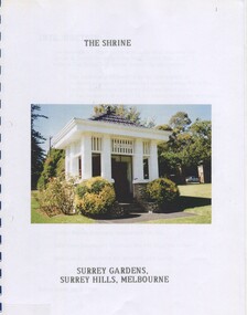 Surrey Hills Historical Society Collection
Book, The Shrine Surrey Gardens, Surrey Hills, Melbourne, Apr-96
This research project is on The Shrine in the Surrey Hills Gardens. It contains a list of those who had enlisted during World War 1, and how it came about to be the first monument of World War 1. Details of the man who carved the wood panels are included.This research project is on The Shrine in the Surrey Hills Gardens. It contains a list of those who had enlisted during World War 1, and how it came about to be the first monument of World War 1. Details of the man who carved the wood panels are included.monuments and memorials, (mr) john kendrick blogg, (mr) john gawler, community gardens, awards, armed forces, centenary methodist church, st.stephen's presbyterian church, "balmoral", house names, (mr) harry 'mafeking' garrett, (mr) arthur (empire) brooks, (mr) james ('rule britannia') sneddon, surrey hills, empire day, church furniture, t f crabb, (mr) walter drummond, surrey hills progress association, (mr) j f woodhead, (mrs) - steele, (mrs) robyn doble -
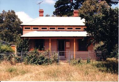 Hume City Civic Collection
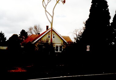
Photograph, early 1990s
The weatherboard house is one of the six weatherboard cottages which were built on the east side of O'Shanassy Street in the early 1900s. It has been listed in the Heritage Study in 1998. Scheduled as having some significance and recommended for further investigation.A coloured photograph of a weatherboard Victorian cottage with an overhanging verandah across the double fronted building. The weatherboard walls are painted biscuit and the window and door frames are tan. A wooden tile trim painted in biscuit, tan and dark green. There are two stepped chimneys protruding from the white painted corrugated iron roof. The overgrown garden has low growing trees and shrubs.george evans collection -
 Surrey Hills Historical Society Collection
Photograph, 11 York Street, Mont Albert, 1974 (1), 1974
This is the home of Ernest Lance Young and Beryl Mair and the childhood home of their children Barbara, Ken and Laurie. Lance was born 24 March 1915 in Surrey Hills, the son of Ernest Augustus Young and Ruby Nichell Whitty. He married Beryl Mair in 1939 and died on 5 October 1999 at Mont Albert. Electoral rolls list him as a manufacturer. His address after marriage was 11 York Street, Mont Albert. He is buried in Box Hill Cemetery (M-*-0867) along with his father. He served in WW2 (Service Number - VX104733 enlisting at St Kilda) and after returning took over his father's business. The Mair family were resident in Barton Street for several generations. Beryl's father Dave Mair was a keen sportsman and founder of the Kangaroo Social Club of cricketers. This is part of a large collection relating to the Mair, Deakin and Young families. Black & white photo of the street view of 11 York Street, Mont Albert. The house is heavily screened by a mature garden with several large trees or shrubs.In red biro on rear: "No 11 York St / 1974" ken young, barbara young, laurie young, laurie newton, beryl mair, ernest lance young, lance young, york street, mont albert -
 Surrey Hills Historical Society Collection
Photograph, 11 York Street, Mont Albert, 1974 (2), 1974
This is the home of Ernest Lance Young and Beryl Mair and the childhood home of their children Barbara, Ken and Laurie. Lance was born 24 March 1915 in Surrey Hills, the son of Ernest Augustus Young and Ruby Nichell Whitty. He married Beryl Mair in 1939 and died on 5 October 1999 at Mont Albert. Electoral rolls list him as a manufacturer. His address after marriage was 11 York Street, Mont Albert. He is buried in Box Hill Cemetery (M-*-0867) along with his father. He served in WW2 (Service Number - VX104733 enlisting at St Kilda) and after returning took over his father's business. The Mair family were resident in Barton Street for several generations. Beryl's father Dave Mair was a keen sportsman and founder of the Kangaroo Social Club of cricketers. This is part of a large collection relating to the Mair, Deakin and Young families. Black & white photo of the street view of 11 York Street, Mont Albert. Taken from diagonally across the street, it shows the end of the house, the driveway and the dividing fence between the property and the adjacent house. The house is heavily screened by a mature garden with several large trees or shrubs.In red biro on rear: "No 11 York St / 1974" ken young, barbara young, laurie young, laurie newton, beryl mair, ernest lance young, lance young, york street, mont albert -
 Surrey Hills Historical Society Collection
Photograph, 11 York Street, Mont Albert, May 1974 (2), 1974
This is the home of Ernest Lance Young and Beryl Mair and the childhood home of their children Barbara, Ken and Laurie. Lance was born 24 March 1915 in Surrey Hills, the son of Ernest Augustus Young and Ruby Nichell Whitty. He married Beryl Mair in 1939 and died on 5 October 1999 at Mont Albert. Electoral rolls list him as a manufacturer. His address after marriage was 11 York Street, Mont Albert. He is buried in Box Hill Cemetery (M-*-0867) along with his father. He served in WW2 (Service Number - VX104733 enlisting at St Kilda) and after returning took over his father's business. The Mair family were resident in Barton Street for several generations. Beryl's father Dave Mair was a keen sportsman and founder of the Kangaroo Social Club of cricketers. This is part of a large collection relating to the Mair, Deakin and Young families. Colour photo of the street view of 11 York Street, Mont Albert. Taken from across the street, it shows only part of the gable of the house. The house is heavily screened by a mature garden with several large trees or shrubs. The fence is low and constructed from roughly faced stone.In blue biro on rear: "11 YORK ST / MONT ALBERT" and separately "May 74" ken young, barbara young, laurie young, laurie newton, beryl mair, ernest lance young, lance young, york street, mont albert -
 Surrey Hills Historical Society Collection
Photograph, 'Graceburn', 17 Trafalgar Street, Mont Albert
Joseph Arthur Bailey, described as a manager in electoral rolls, came to Surrey Hills some time before 1903. He was born in Brighton in 1873 and died in Burwood in 1929 and is buried in Box Hill Cemetery. He was the son of George Bailey and Georgina Hardwick, who lived in Healesville for a time but 'retired' to Surrey Hills where they are listed at 'Claremont' in Mont Albert Road in 1919. Joseph married Eleanor Beatrice Greenhill in 1897. They had 3 sons - Rupert Aitken (who served in WW1); Kenneth Alan and Edwin George. Prior to living in Trafalgar Street they lived at 9 Victoria Crescent. A black and white photograph of a brick house in the californian bungalow style with a well-established garden, as viewed from one side.trafalgar street, graceburn, house names, 1919, californian bungalow, box hill cemetery, joseph arthur bailey, mrs eleanor beatrice bailey, miss eleanor beatrice greenhill, mr rupert aitken bailey, mr kenneth alan bailey, mr edwin george bailey -
 Surrey Hills Historical Society Collection
Photograph, Falconer family home, 'Legerton' at 15 Albert Crescent, 1920
Date is approximate. House was built in 1910 and has been demolished. The woman on the verandah is probably Mrs P Falconer, Ron Falconer's mother. Her full name was Emily Victoria Aird (1884-1957), daughter of James Bromich Aird and Sarah Ann (nee Edwards). She married Patrick Henry Falconer on 11 December 1907 in Blackburn. The Falconer family lived in Albert Crescent for many years. Listed in electoral rolls in 1916 through to the 1950s. By 1963 the family were at 33 Weybridge Street, Surrey Hills. Emily and Patrick Henry Falconer had 4 children: Ronald Keith (b1908); Hilda Irene (b 1910); Harold Leslie (b 1913) and Hilah (b 1915). James and Sarah Aird are buried in Box Hill Cemetery.Black and white photo showing a close-up view of the Falconer family home, 'Legerton' at 15 Albert Crescent, Surrey Hills with a woman at the entrance. It is a timber Edwardian home with simple fretwork on the verandah and a mature garden which partially obscures the entrance.edwardian style, legerton, albert crescent, miss emily victoria aird, mrs emily victoria falconer, patrick henry falconer, ronald keith falconer, miss hilda irene falconer, harold leslie falconer, hilah falconer -
 Kew Historical Society Inc
Plan, Melbourne & Metropolitan Board of Works : Borough of Kew : Detail Plan No.1574, 1905
The Melbourne and Metropolitan Board of Works (MMBW) plans were produced from the 1890s to the 1950s. They were crucial to the design and development of Melbourne's sewerage and drainage system. The plans, at a scale of 40 feet to 1 inch (1:480), provide a detailed historical record of Melbourne streetscapes and environmental features. Each plan covers one or two street blocks (roughly six streets), showing details of buildings, including garden layouts and ownership boundaries, and features such as laneways, drains, bridges, parks, municipal boundaries and other prominent landmarks as they existed at the time each plan was produced. (Source: State Library of Victoria)This plan forms part of a large group of MMBW plans and maps that was donated to the Society by the Mr Poulter, City Engineer of the City of Kew in 1989. Within this collection, thirty-five hand-coloured plans, backed with linen, are of statewide significance as they include annotations that provide details of construction materials used in buildings in the first decade of the 20th century as well as additional information about land ownership and usage. The copies in the Public Record Office Victoria and the State Library of Victoria are monochrome versions which do not denote building materials so that the maps in this collection are invaluable and unique tools for researchers and heritage consultants. A number of the plans are not held in the collection of the State Library of Victoria so they have the additional attribute of rarity.Original survey plan, issued by the MMBW to a contractor with responsibility for constructing sewers in the area identified on the plan within the Borough of Kew. The plan was at some stage hand-coloured, possibly by the contractor, but more likely by officers working in the Engineering Department of the Borough and later Town, then City of Kew. The hand-coloured sections of buildings on the plan were used to denote masonry or brick constructions (pink), weatherboard constructions (yellow), and public buildings (grey). This plan shows several very large houses, particularly along Glenferrie Road, and the area now occupied by Ruyton Girls’ School. ‘Tarring’ (incorrectly spelled here as ‘Karring’) was built for Henry Henty in 1872, on part of his original allotment of 20 acres, and ‘Mount View’, which retains its original building and the fountain in the front garden, is part of Ruyton’s Junior School. The most significant change to Tarring and its grounds since 1903, involve the removal of a number of the outbuildings, including a Burmese temple, bought by Henty from the Burmese Exhibit at the Great Exhibition of 1880. It is shown on the plan as a summerhouse. The two-storey mansion, on the corner of Glenferrie Road and Wellington Street, was built in 1891 by leading architect Alfred White as his own home. Having an initial N.A.V. of £160, the house was purchased by a warehouseman Henry Lister, by 1900, when the N.A.V. was recorded at £111. By the turn of the century the house was known as ‘Comaques’. By contrast, much smaller houses are shown in Scott and Byron Streets, including a tiny Mission Hall in Byron Street, which belonged to the Anglican Church from at least 1903 to 1917.melbourne and metropolitan board of works, detail plans, maps - borough of kew, mmbw 1574, cartography -
 Kew Historical Society Inc
Plan, Melbourne and Metropolitan Board of Works, Borough of Kew : Detail Plan No.1580, 1904
The Melbourne and Metropolitan Board of Works (MMBW) plans were produced from the 1890s to the 1950s. They were crucial to the design and development of Melbourne's sewerage and drainage system. The plans, at a scale of 40 feet to 1 inch (1:480), provide a detailed historical record of Melbourne streetscapes and environmental features. Each plan covers one or two street blocks (roughly six streets), showing details of buildings, including garden layouts and ownership boundaries, and features such as laneways, drains, bridges, parks, municipal boundaries and other prominent landmarks as they existed at the time each plan was produced. (Source: State Library of Victoria)This plan forms part of a large group of MMBW plans and maps that was donated to the Society by the Mr Poulter, City Engineer of the City of Kew in 1989. Within this collection, thirty-five hand-coloured plans, backed with linen, are of statewide significance as they include annotations that provide details of construction materials used in buildings in the first decade of the 20th century as well as additional information about land ownership and usage. The copies in the Public Record Office Victoria and the State Library of Victoria are monochrome versions which do not denote building materials so that the maps in this collection are invaluable and unique tools for researchers and heritage consultants. A number of the plans are not held in the collection of the State Library of Victoria so they have the additional attribute of rarity.Original survey plan, issued by the MMBW to a contractor with responsibility for constructing sewers in the area identified on the plan within the Borough of Kew. The plan was at some stage hand-coloured, possibly by the contractor, but more likely by officers working in the Engineering Department of the Borough and later Town, then City of Kew. The hand-coloured sections of buildings on the plan were used to denote masonry or brick constructions (pink), weatherboard constructions (yellow), and public buildings (grey). The area represented in this detail plan has undergone significant change during the 20th century. The widening of High Street in the 1930s and 1950s involved the shops on the south side of High Street being demolished and later rebuilt to fit the widened street. Another significant loss was the mansion ‘Drayton’ fronting Wellington Street, owned at this stage by Susannah Fenton. Her family name would later to be given to Fenton Way, which was to be built over the grounds of the house following its demolition. The plan of the garden is particularly interesting, containing a batten dome fronting Wellington Street, an ornamental pond, a fountain and a brick and glass conservatory. The notes by the plumbing contractor on this plan are particularly detailed. Pink borders delineate the ownership of the varying parcels of land. Some of the better known owners listed include the real estate agent Cr. Henry de Castres Kellett (bt) and John Padbury, the funeral director. This particular plan provides a clear view of the configuration of the Kew Junction in 1903 and the commercial buildings that surrounded it.melbourne and metropolitan board of works, detail plans, maps - borough of kew, mmbw 1580, cartography -
 Kew Historical Society Inc
Plan - Subdivision Plan, H C Crouch, Old Golf Links Estate, 1930s
The land in North Kew between the Outer Circle Railway and the River Yarra was released in sections. This release included 80 lots. Most of this area was released during the Depression years in the early 1930s.Subdivision plans are historically important documents used as evidence of the growth of suburbs in Australia. They frequently provide information about when the land was sold on which a built structure was subsequently constructed as well as evidence relating to surveyors and real estate and financial agents. The numerous subdivision plans in the Kew Historical Society's collection represent working documents, ranging from the initial sketches made in planning a subdivision to printed plans on which auctioneers or agents listed the prices for which individual lots were sold. In a number of cases, the reverse of a subdivision plan in the collection includes a photograph of a house that was also for sale by the agent. These photographs provide significant heritage information relating house design and decoration, fencing and household gardens.One part of a massive subdivision of the Old Golf Links Estate in North Kew of 80 allotments bordering Sutherland Avenue, Ramsay Avenue, Belford Road, Beresford Street and Coleman Avenue. Inset on the plan at the top left, the route of the Outer Circle Railway is clearly marked. The Kew Golf Links is identified in its current location. The land on which Greenacres Golf Club was to be constructed is at this time marked as ‘Recreation Ground’. The ‘new bridge’ over the Yarra at Burke Road is also marked on the inset map. The Plan identifies the surveyor (sic) H.C. Crouch BCE MVIS, 443 Little Collins St., Melbourne. The date of the subdivision auction sale in identified as Saturday September 25th at three o'clock.Annotations: "E" top left. "Golf Links" top right. Lots 73-76 ticked and listed as "6" poundssubdivisions -- kew (vic.), old golf links estate -
 Kew Historical Society Inc
Photograph - Cosy Five Roomed Rough Cast Bungalow, Kew, J E Barnes, c.1920
Subdivision plans are historically important documents used as evidence of the growth of suburbs in Australia. They frequently provide information about when the land was sold on which a built structure was subsequently constructed as well as evidence relating to surveyors and real estate and financial agents. The numerous subdivision plans in the Kew Historical Society's collection represent working documents, ranging from the initial sketches made in planning a subdivision to printed plans on which auctioneers or agents listed the prices for which individual lots were sold. In a number of cases, the reverse of a subdivision plan in the collection includes a photograph of a house that was also for sale by the agent. These photographs provide significant heritage information relating house design and decoration, fencing and household gardens. The photograph is also aesthetically significant as it was taken by J. E. Barnes, a nationally significant photographer. He was the most important photographer to have worked in Kew. He was active as a photographer in the district from c.1906 until his death in 1921. Best known as 'the Embarkation Photographer' (see the Australian War Memorial collection), Josiah Earl Barnes was also the official photographer employed by the Borough (and later Town, then City) of Kew. He clearly also completed commercial jobs for local businesses, as is the case in this photograph of a house for a local real estate and financial agent. A modest weatherboard house with rough-cast rendered walls. The gabled entrance incorporates elements of the Japanese aesthetic. The strong lines of the dark timber gable are reinforced by the colour and shape of the pickets in the fence. In contrast to an earlier period, the chimneys appear truncated. The use of extensive double-hung sash windows in the front rooms reflects a new interest in light in houses. The use of separate sunshades over windows in an earlier period is here replaced by an extension of the roofline over the window. The photographer Josiah Barnes died in 1921; so, the photograph of the house must predate this date. The location of the house, which was advertised for sale, has to date not been identified. Illegible inscription. Photographer's information on mount.josiah earl barnes, j e barnes, photography - kew, interwar housing - victoria, 1920s housing - kew -
 Kew Historical Society Inc
Photograph - 2 Young Street, Kew, Paramount Photos, 1920s
Subdivision plans are historically important documents used as evidence of the growth of suburbs in Australia. They frequently provide information about when the land was sold on which a built structure was subsequently constructed as well as evidence relating to surveyors and real estate and financial agents. The numerous subdivision plans in the Kew Historical Society's collection represent working documents, ranging from the initial sketches made in planning a subdivision to printed plans on which auctioneers or agents listed the prices for which individual lots were sold. In a number of cases, the reverse of a subdivision plan in the collection includes a photograph of a house that was also for sale by the agent. These photographs provide significant heritage information relating house design and decoration, fencing and household gardens.A prepossessing, large home constructed in the Arts and Crafts style. Located on the banks of the Yarra at 2 Young Street, Kew overlooking the factories of Richmond, the design of the house takes account of the gradient with the addition of a level below the front entrance. The elegant roof includes a number of projecting gables and dormers. The gables are typically half-timbered and rendered. In addition to the asymmetrically placed portico, there are at least two open verandas, supported by timber pillars and with roofs that reflect the overall pitch of the roof of the housereal estate photographs, 2 young street - kew -
 Kew Historical Society Inc
Photograph - 29 Uvadale Grove, Kew, 1920
The numerous subdivision plans in the Kew Historical Society's collection represent working documents, ranging from the initial sketches made in planning a subdivision to printed plans on which auctioneers or agents listed the prices for which individual lots were sold. In a number of cases, the reverse of a subdivision plan in the collection includes a photograph of a house that was also for sale by the agent. Subdivision plans are historically important documents used as evidence of the growth of suburbs in Australia. They frequently provide information about when the land was sold on which a built structure was subsequently constructed as well as evidence relating to surveyors and real estate and financial agents. These photographs provide significant heritage information relating house design and decoration, fencing and household gardens.When 29 Uvadale Grove, Kew was offered for sale it was described as: ‘Kew. Fine locality, 3 minutes Cotham Road. Splendidly built 6 roomed Brick Villa. Rooms 17 x 14, 16 x 13, &c. Beautifully fitted throughout. Land 70 x 134 to ROW.’ The price was advertised as being £1,400. The house exhibits key features of Federation architecture such as the gabled roof with a facing of half-timber and stucco. The veranda has a curved corrugated iron roof supported by timber pillars and fretwork. The slate roof with terra cotta ridging and finials marks a transition to the more common use of Marseilles tiles in Federation architecture.subdivisions - kew (vic.), 29 uvadale grove - kew (vic.) -
 Kew Historical Society Inc
Photograph - 'Mount Eri', 9 Highbury Grove, 1919
Subdivision plans are historically important documents used as evidence of the growth of suburbs in Australia. They frequently provide information about when the land was sold on which a built structure was subsequently constructed as well as evidence relating to surveyors and real estate and financial agents. The numerous subdivision plans in the Kew Historical Society's collection represent working documents, ranging from the initial sketches made in planning a subdivision to printed plans on which auctioneers or agents listed the prices for which individual lots were sold. In a number of cases, the reverse of a subdivision plan in the collection includes a photograph of a house that was also for sale by the agent. These photographs provide significant heritage information relating house design and decoration, fencing and household gardens.A photograph of Mount Eri, 9 Highbury Grove, an 11-room house for sale near the junction of Cotham and Glenferrie Roads. The substantial red brick, slate-roofed house and its location are not identified in the photograph, although the extent of the house is noted. It was described then as ‘well situated’ and close to 3 trams. Mathers, a financial agent in Cotham Road, placed advertisements about the sale of the property in The Argus in May and June 1919. The advertisement additionally refers to a billiard room and asserts that the house has every modern convenience. An annotation on the plan indicates that the house, with tennis court, was sold for £1960. Following extensive research, the house has now been conclusively identified, albeit extended and rendered. The house was originally built in the 19th century as a school and for much of the 20th century was used as a venue for receptions. -
 Kew Historical Society Inc
Photograph - Victorian Villa, High Street, c.1922
Subdivision plans are historically important documents used as evidence of the growth of suburbs in Australia. They frequently provide information about when the land was sold on which a built structure was subsequently constructed as well as evidence relating to surveyors and real estate and financial agents. The numerous subdivision plans in the Kew Historical Society's collection represent working documents, ranging from the initial sketches made in planning a subdivision to printed plans on which auctioneers or agents listed the prices for which individual lots were sold. In a number of cases, the reverse of a subdivision plan in the collection includes a photograph of a house that was also for sale by the agent. These photographs provide significant heritage information relating house design and decoration, fencing and household gardens.An old inscription on this photograph identifies it as ‘an elegant timber villa in High Street. It occupied part of Lot 91, bought by Edward Glyn in the land sale of 16th October 1851, and run as a flower farm’. The subdivision called the ‘Flower Farm Estate’ in East Kew occurred in 1922. [The subdivision plan is on the reverse of this photo.] The Estate included 61 lots on either side of Boorool Road between High Street and Harp Road. In the MMBW Detail Plan 2017 of 1926, a number of these new villas had already been built. Matching houses with MMBW maps can always be a challenge, however if this house was near the corner of Boorool Road and High Street, it seems to fit the profile of a house called ‘Maxton’ (demolished).Photographer's name on photograph, lower right, and stamp on mount lower right: "A. Aberline, Glenferrie".houses - maxton - high street - kew (vic.), violet farm estate, subdivisions - kew (vic.) -
 Kew Historical Society Inc
Photograph - 8 roomed DF Brick Villa, Kew, J E Barnes, c.1920
Subdivision plans are historically important documents used as evidence of the growth of suburbs in Australia. They frequently provide information about when the land was sold on which a built structure was subsequently constructed as well as evidence relating to surveyors and real estate and financial agents. The numerous subdivision plans in the Kew Historical Society's collection represent working documents, ranging from the initial sketches made in planning a subdivision to printed plans on which auctioneers or agents listed the prices for which individual lots were sold. In a number of cases, the reverse of a subdivision plan in the collection includes a photograph of a house that was also for sale by the agent. These photographs provide significant heritage information relating house design and decoration, fencing and household gardens. The photograph is of additional aesthetic significance as it was photographed by J. E. Barnes. Josiah Earl Barnes is a nationally significant photographer. He was also the most important photographer to have worked in Kew. He was active as a photographer in the district from c.1906 until his death in 1921. Best known as 'the Embarkation Photographer' (see the Australian War Memorial collection), J. Earl Barnes was also the official photographer employed by the Borough (and later Town, then City) of Kew. He clearly also completed commercial jobs for local businesses, as is the case in this photograph of a house for a local real estate and financial agent.A photograph, mounted on board of a double fronted Federation-era brick villa in Kew, photographed for a local real estate agent and financier by J. E. Barnes of Kew. On the reverse of the photograph is a subdivision plan for the Normanby Estate, East Kew - 2016.0039.1. As can be seen from the image, there is a large tear on the surface of the photograph.The brown card on which the photograph is mounted includes the following handwritten description, which may aid the identification of the house: "Kew, 3 minutes from tram, 8 roomed DF Brick Villa, tile roof including two attics, sleepout, bathroom, heater, E Light, Entrance Hall, double doors, leadlights, laundry, garden, lawns, land 75 x 170, 1975 pounds". Also photographers inscription on mount, lower left: J. E. Barnes / Photo / Phone 1966 Haw. KEW.j. e. barnes, josiah earl barnes, j. earl banes - photographer, architecture - federation style, houses - kew, real estate photographs -
 Kew Historical Society Inc
Photograph - W.B. Villa, Kew, c.1919
The photograph offers significant information relating to late Victorian / Federation colour schemes and fencing.The block fronted villa has a corrugated iron roof and a flat projecting verandah, ornamented with a trellis design of timber. The front window features a timber shade, mounted on brackets. The treatment of the block-fronted panels shows that there is an attempt to highlight imitation quoining through use of a darker colour. The windows and door are also in this darker shade. The front fence and gate are made of wooden pickets. It is unlikely that the photograph was taken at the time of the villa's construction given the size of the shrub/tree in the front garden.Subdivision plans are historically important documents used as evidence of the growth of suburbs in Australia. They frequently provide information about when the land was sold on which a built structure was subsequently constructed as well as evidence relating to surveyors and real estate and financial agents. The numerous subdivision plans in the Kew Historical Society's collection represent working documents, ranging from the initial sketches made in planning a subdivision to printed plans on which auctioneers or agents listed the prices for which individual lots were sold. In a number of cases, the reverse of a subdivision plan in the collection includes a photograph of a house that was also for sale by the agent. These photographs provide significant heritage information relating house design and decoration, fencing and household gardens.A real estate photograph, mounted on brown card, showing a double fronted weatherboard villa, located in Kew, Victoria. On the reverse of the photograph is a subdivision plan for the Altyre Estate.Stamped on mount: Top - "KEW. Close tram. Fine View. / W.B. Villa Containing 8 Rooms. / Up-to-date Conveniences. EL Etc." Below - "Land 40 x 165. 615 pounds. Sold"houses - kew, real estate photographs -
 Kew Historical Society Inc
Plan - Subdivision Plan, J R Mathers & McMillan, Normanby Estate, c.1913
The Kew Historical Society's map collection includes a substantial number of real estate subdivision plans, mainly of Kew but also of surrounding suburbs in Melbourne. Most of the subdivision plans date from the 1920s and 1930s when the districts old homes and local farmland were being split up to accommodate residential growth in the postwar period. These early plans were assembled by a local firm, Jas R Mather & McMillan, which had an office in Cotham Road. Many of the plans, and sometimes photos, were annotated by the agents.Subdivision plans are historically important documents used as evidence for the growth of suburbs in Australia. They frequently provide information about when the land was sold as well as evidence relating to surveyors and real estate and financial agents. The numerous subdivision plans in the Kew Historical Society's collection represent working documents, ranging from the initial sketches made in planning a subdivision to printed plans on which auctioneers or agents listed the prices for which individual lots were sold. In a number of cases, the reverse of a subdivision plan in the collection includes a photograph of a house that was also for sale by the agent. These photographs provide significant heritage information relating house design and decoration, fencing and household gardens.The photograph may also be aesthetically significant depending on the importance of the photographic atelier.The Normanby Estate, which was adjacent to Normanby Road, Kew East, included thirty-one lots for sale. Streets on the subdivision plan include Adeney Avenue, Park Hill Road, Normanby Road, Weir Street and Wharton Street. Cotham Road and its tramway are shown nearby. The plan is interesting as it shows Wharton Street, named after the architect and town planner George Wharton, who was the first chairman of the Municipality of Kew. The street was to later be renamed Cecil Street. Also shown are proposed ‘Municipal Gardens’ where Parkhill Drive is now located."D" in top left corner. Stamped auctioneers contact details: "Jas. R. Mathers & Son & McMillan / Auctioneer & Land Salesmen, / 271 Collins Street / Melbourne" and Jas. R. Mathers / Estate & Financial Agent / Cotham Road / Kew".weir street - kew, wharton street - kew, normanby road - kew, cotham road - kew, municipal gardens - kew, park hill parkhill road - kew, braemar - kew, subdivision plans - kew -
 Kew Historical Society Inc
Document, Executor's Auction, Sunday 24th October 1931, "Goldthorns", Normanby Road, Corner of Argyle Road, Kew, 1931
Rare real estate brochure relating to the sale of a historically significant Kew mansion. The rarity the document is increased due to the photographs of the front of the house and of the extensive rear garden.Four page flyer advertising the sale of Goldthorns in Normanby Road, Kew in October 1931. The flyer contains a photograph of the front of the house, a list of its rooms, a site plan (including possible subdivisions). and a photo of the rear garden.goldthorns - normanby road, kew (vic), real estate - kew (vic), griffith family - kew (vic), gardens - kew (vic), subdivisions - kew (vic) -
 Kew Historical Society Inc
Plan, Studley Heights Estate, 1936
Pru Sanderson, in her groundbreaking ‘City of Kew Urban Conservation Study : Volume 2 - Development History’ (1988), summarised the periods of urban development and subdivisions of land in Kew. The periods that she identified included 1845-1880, 1880-1893, 1893-1921, 1921-1933, 1933-1943, and Post-War Development. These periods were selected as they represented periods of rapid growth or decline in urban development. An obvious starting point for Sanderson’s groupings involved population growth and the associated economic cycles. These cycles also highlighted urban expansion onto land that was predominantly rural, although in other cases it represented the decline and breakup of large estates. A number of the plans in the Kew Historical Society’s collection can also be found in other collections, such as those of the State Library of Victoria and the Boroondara Library Service. A number are however unique to the collection.Subdivision plans are historically important documents used as evidence of the growth of suburbs in Australia. They frequently provide information about when the land was sold on which a built structure was subsequently constructed as well as evidence relating to surveyors and real estate and financial agents. The numerous subdivision plans in the Kew Historical Society's collection represent working documents, ranging from the initial sketches made in planning a subdivision to printed plans on which auctioneers or agents listed the prices for which individual lots were sold. In a number of cases, the reverse of a subdivision plan in the collection includes a photograph of a house that was also for sale by the agent. These photographs provide significant heritage information relating house design and decoration, fencing and household gardens.The ‘Studley Heights Estate’ on the South Side of Studley Park Road was launched in 1936. The seventeen allotments in the subdivision fronted Hyton Crescent and Studley Park Road.subdivision plans - kew, studley heights estate